South Dakota Map
|
 |
 |
Where Is South Dakota?
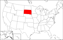
Looking at the 50 state map to the right, you will see South Dakota's location highlighted. The State of South Dakota is bordered by North Dakota on the north, by Nebraska on the south, and by Minnesota on the east. South Dakota is bounded by Iowa on the southeast, by Montana on the northwest, and by Wyoming on the southwest.
South Dakota Maps
South Dakota is the 16th largest state in the United States; its land area is 75,885 square miles (196,542 square kilometers). The state is partitioned into 66 counties. This South Dakota map site features road maps, topographical maps, and relief maps of South Dakota. The detailed, scrollable road map displays South Dakota counties, cities, and towns as well as Interstate, U.S., and South Dakota state highways. The pannable, scalable South Dakota street map can be zoomed in to show local streets and detailed imagery.
South Dakota Highway Map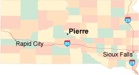 Click on the highway map thumbnail
to view a scalable South Dakota road map. |
SD Topo Map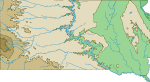 Click map to enlarge.
|
SD Relief Map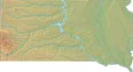 Click map to enlarge.
|
The detailed South Dakota map and the regional South Dakota map display cities, roads, rivers, and lakes as well as terrain features. The detailed map shows only the State of South Dakota, while the regional map shows South Dakota and the surrounding region.
South Dakota Infrastructure > South Dakota Airports
In 2005, the population of South Dakota was estimated at 774,883, which is about 10.2 people per square mile. In 2010, South Dakota's population rose to 814,180 people. More recently, in the 2020 census, the South Dakota population was 886,667. The state's Interstate Highways include I-29 and I-90.
South Dakota Topography
South Dakota was named after the Dakota tribe of Sioux Indians. "Dakota" is the Sioux word for "friend". Both North Dakota and South Dakota were admitted to statehood in the USA on November 2, 1889. North Dakota's terrain rises gradually from the east to the Black Hills in the west and the Badlands in the southwest. The Missouri River bisects the state. Native American Reservations cover large areas of western North Dakota. The most notable tourist attraction is Mount Rushmore, in the Black Hills region. Visit the official South Dakota tourism site and South Dakota Atlas for South Dakota travel and tourism information.
Other Maps of South Dakota
This South Dakota reference map shows major cities, roads, railroads, and physical features in South Dakota.Several map publishing companies offer printed maps of South Dakota. For example, Omni Resources offers several maps of South Dakota that feature points of interest, airports, and parks, as well as selected local attractions and insets of major South Dakota cities.
All rights reserved.
Certain maps hereon are © Map Resources or Digital Wisdom.
To facilitate browsing, certain external links will open in new windows.
South-Dakota-Map.org Editor, State Maps, PO Box 828, Barnegat, NJ 08005.